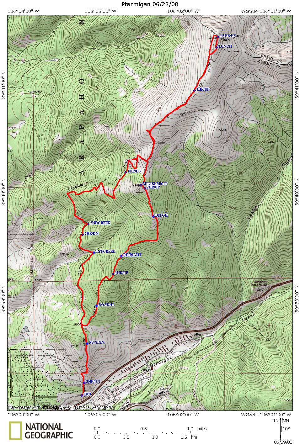
Ptarmigan Summit / Loop June 22, 2008
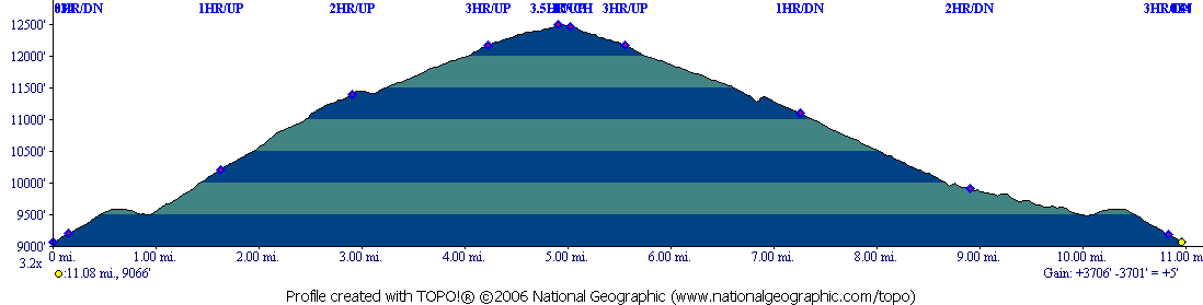
Distance: About 5 miles up and 6 miles down
Duration: 7 hours including lunch (6 hours for Mike and Madalyn)
Hikers: Don, Marina, Mike, Madalyn
As you can see from the main hikes page,
this is a favorite hike. Our times are also getting better as Marina
and I loose weight and get into shape. This was 90 minutes batter than
my previous summit in 2006
This was hiking up the back steep way and down the main front way:
I think only 1 bad point on the gps on the way down.
To get to the trail head for this hike, at the CO 9 (Blue River
Parkway) and Rainbow Drive intersection, head east on Rainbow Drive.
Take a right at the first stop sign, Tanglewood Lane. Head up
Tanglewood until you come to Ptarmigan Trail (this is a road not a
trail). Turn right on to Ptarmigan Trail. The road climbs and then at
the intersection of 2020 it turns into a dirt road. Continue following
the dirt road until you arrive at the parking area for the actual
Ptarmigan trail.
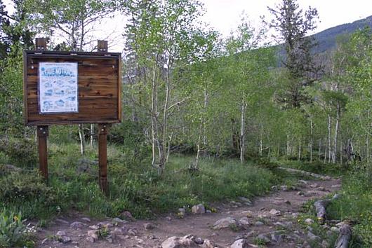
We started the hike at 8:30 in the morning, as usual times are shown on
the map based on the gps. The hike starts off through a small grove of
Aspens, then rejoins the road for a short distance, then climbs through
a Sage Meadow. At about 0.68 miles you come to the end of the meadow
and a large sign that will indicate you are entering National
Forest land.
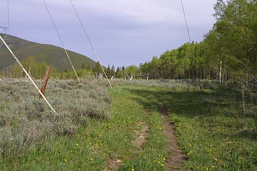
You then get a slight down hill through the Aspens. At 0.85 miles you
reach the power lines. At this point the trail splits. Most people
continue straight, but there is an alternative by taking a hard right.
The straight trail is about a mile longer to the summit and not quite
as steep. It offers views of the Gore Range through the dying pines.
The steeper way can offer views to the south if you occasionally turn
around while you are hiking. I prefer the steeper route.
A more in depth description of this route, divided up into sections can
be found on my 2006 summit page.
After leaving the power lines the steeper route curves gently around to
your left and starts a gentle climb.
A little over one mile in, you come to a "T" intersection where you can
either go left or right. Go left and continue climbing. This is an old
road of some sort and has pits dug into it every 20 to 50 yards all the
way to what I call the mini summit. At this point Michael and Madalyn
took off ahead of us and we met back up at the mini summit. The map
above shows two branch points that you may see on the way up, the first
one to your left is a bit hard, the second on your right is easier.
Just keep following the pits in the road.
When you reach around 11,000 feet in elevation, you start to hit
high alpine meadows. Be sure to occasionally stop and look back as the
views south are stunning. At 3 miles you hit the mini-summit. At this
point the road with the pits ends. Look north and you will see the
trail take a slight descent, then climb again. At 3.25 miles you will
rejoin the longer trail and enter the Eagles Nest Wilderness. There is
a sign here. At this point you are at tree line. Continue up
sometimes dodging snow fields as we did until 3.85 miles where there is
a sign indicating a trail branches off to Ptarmigan Pass. As of this
writing, I have not hiked this. Despite what the profile says, at this
point the climb becomes a bit more gentle and the summit is obtained at
approximately 5 miles (6 if you took the main route).
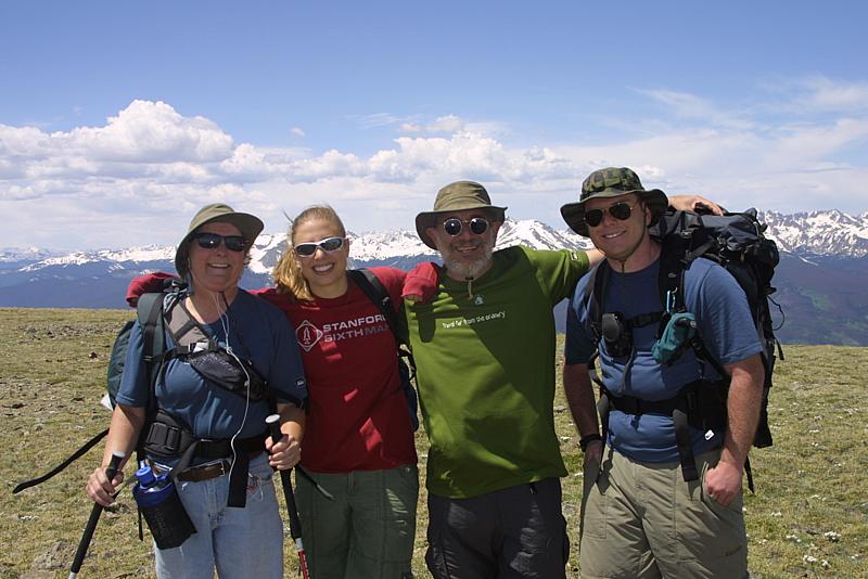
As we were not the only ones to make the summit we got a group pic. We
then moved a bit off of the summit to get out of the wind, had lunch
and then descended via the long route. At the Wilderness sign, Madalyn
and Michael took off and made it to the car an hour ahead of Marina and
Don.
On the descent, once you have past the Wilderness sign, you go through
a series of switch backs until approximately mile 8.4. At that point
you parallel CO 9 continuing a more gentle descent until you rejoin the
steep trail at the power lines, at mile 10.25. Watch out for mountain
bikers from the Wilderness sign back to the trail head. They sometimes
use this trail. At 8.85 miles you will cross a small creek, and again
at 9.3 miles.
Gore Range Outfitters also
uses this trail for some of their rides.
More people and scenery pictures
here
Flower pictures here.
Back to Hikes Page
Back to Snowedunder Home
Feedback to:

This page last updated July 6, 2008