Buffalo from Buffalo Cabin Trailhead - August 24, 2008
 available on this hike.
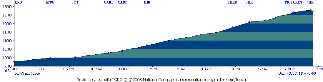
Distance: at leas 2.7 miles one way
Times:
Up: 4 hours
Down: 3 hours (with photos)
Hikers: Don, Marina, David
Rating: Most Difficult
New trail from previous attempts which can be found here:
First attempt at Buffalo
Buffalo Summit from Ruby Ranch
This was our first time on the "re-routed" trail. A significant portion
of the trail is through a large boulder field in order to avoid the
erosion that was in the avalanche shoot. While we were good hikers and
did not stray from the "official" route. We did see hikers avoid the
boulder field and go up the part of the old way ( basically from the
point marked "screelow" on the topo.
If there is a danger of thunderstorms while you would be out on this
hike, you probably should wait till another day. You can't run down the
boulder field.
As David was with us, I asked, and he accepted, to carry my tripod up,
which I would not need till the summit.
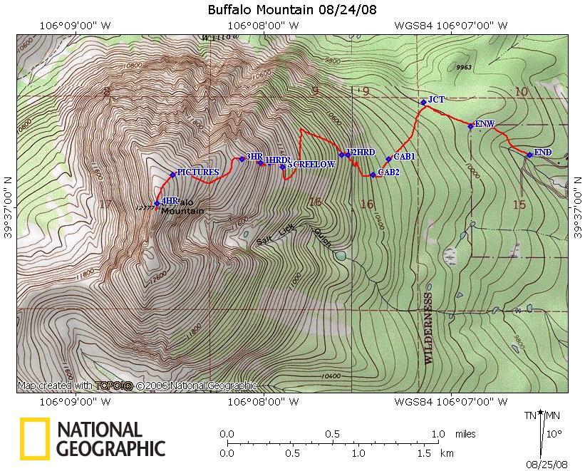
The trail starts out at the top of Mesa Cortina, on the Buffalo Cabin
trail. The trail starts off with a gentle climb through Lodgepole
(mostly dead due to the Pine Bark Beetle). At .33 miles you cross
into the Eagle's Nest Wildernest. At .55 miles you reach a 4 way
junction. If you turn right and head downhill you reach the Royal
Buffalo trailhead, going straight (actually jog left then right) and
you will cross the flanks of Buffalo and end up on the Gore Range
Trail. We want to turn left and head up the mountain. The trail starts
to get a bit steeper and at 0.86 and 0.91 miles you reach the two
cabins. After the 2nd cabin, the new trail leaves the old trail,
heading WNW and continuing to climb. The Forest Service cleverly routed
the trail to hit a boulder field low down on the flanks of the
mountain. This boulder field was no problem. The trail continues to
climb and you will occasionally start to see views of surrounding
mountains and Lake Dillon. At 1.45 miles you hit a major switchback and
head South. At 1.66 miles you cross into the avalanche shoot and
quickly turn around again and reach the large boulder field at 1.79
miles. I did not get any pictures of the field as I had my camera
stowed away in the backpack. If I were smart, I would have stowed away
the hiking poles as well for this portion. From 1.79 miles to about
2.18 miles you are in this field continuing to work your way
upwards. With no trees, the views become great looking at Ptarmigan and
Lake Dillon. After finally rounding a "little knob" (play with the kml
file and Google Earth), you come to the top of the smaller shoot that
is sometimes skied in the spring. Looking from CO 9, this is the left
shoot. You rejoin high alpine vegetation (above tree line) and work
your way from the top of the left shoot to the top of the wider right
hand shoot (left side as it is a "Y" ), then continue up a scree field
and just before the summit, hike a ridge with a gentle slope that will
take you to the summit. Great views towards the West are finally shown
to you. The mountain drops off quite steeply on the West side (although
the East side is also fairly steep).
We ate our lunch on the summit. The weather started to turn and we
headed back down. I took the tripod from David and stopped once for
pictures of Ruby Ranch (since I have been spending more time in the
front of my yard cutting trees, my house is more visible from Ptarmigan
than from Buffalo, but that will change as I take down more trees on
the West side of our property). A small thunderstorm developed over the
mountain and did not really move. We were fortunate in that there was
no lightening nearby and the hail and rain that we were pelted with in
the boulder field was very light. I would not have liked to have been
caught in a stronger storm.
Pictures from the hike (no flowers though) here.
Feedback to:

Back to Hikes Page
Back to Snowedunder Home
This page last updated September 14 2008