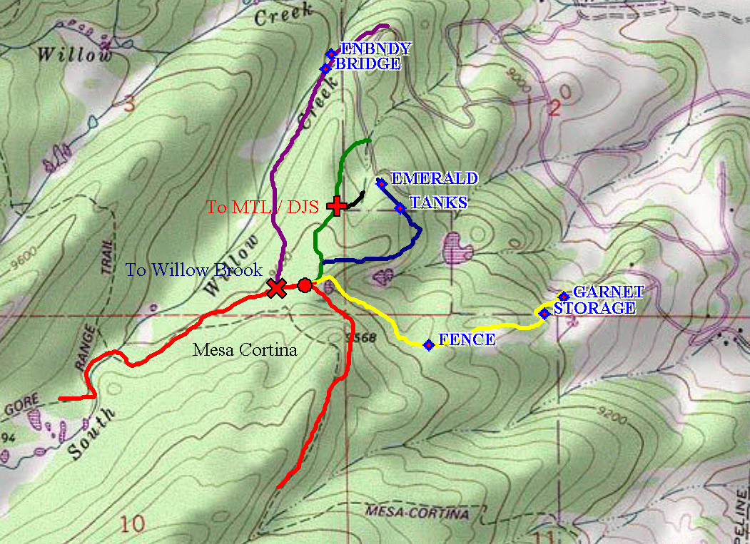
Ruby Ranch Trails
I have taken my gps, and walked the trails which connect Ruby Ranch to
the Eagle's Nest Wilderness. I have produced the following map:
A larger version can be had by clicking on the image
An explanation of the map:
-
The Mesa Cortina trail, shown in red does not actually agree with the USGS
topos in the vicinity of the Ranch. My actual plots are shown in red.
-
The trail from filing 1 is shown in yellow. It leaves from Garnet, climbs
a road to storage tanks and then follows the route shown. You will cross
a fence line that does not seem to correlate with any current boundaries,
then pass the old beaver dams and join the Mesa Cortina at the point indicated
by the red circle.
-
The purple trail leaves from Emerald Road by the lower water storage tanks,
and quickly joins Willow Brook where the Ruth Ditch begins. Soon after
crossing into the Eagle's Nest Wilderness (indicated by ENBNDY on the map)
you come to a bridge which the hikers coming in from the Willow Brook sub-division
join the trail. The trail joins the Mesa Cortina indicated by the red "X"
-
The green trail starts on Emerald in between the Baldwin's (Lot 42) and
the Lyons (Lot 41). Before it joins the Mesa Cortina, trails come in from
my house (black) and the End of Emerald (blue)
-
The black trail is how I go in from my property (Lot 40 - 1228 Emerald)
and joins the green at the red cross.
-
The blue trail starts at the very end of Emerald, climbs up to the upper
water storage tanks, then drops down more or less unmarked until it reaches
the trail that comes up from Tom Festa and Linda Lichtendahl's house. I
have not indicated their trail on the map as it is not public.
Pictures showing various landmarks for navigation will be posted at a later
date.
This page authored by Don Samuels
Return to Snowedunder/RubyRanch
Return to Snowedunder Home
This page last revised on August 4, 2002
Maps are derived from copyrighted material using Wildflower or TOPO!
(the topo maps) software, I will put a copyright of Don Samuels on (2002),
in addition to TOPO and possibly USGS.